To the discerning eye, other mountains are visible – giants between 23,000 and 26,000 feet high. Not one of their slenderer heads even reaches their chief’s shoulder. Beside Everest they escape notice, such is the pre-eminence of the greatest. (George Mallory, 1922)
The climbing season on Mount Everest peaks in late May and early June every year. Extreme weather patterns at this location and altitude mean the main climbing season is remarkably short, perhaps only a few weeks between the winter freeze and monsoon storms.
Even within that time, the precise location of the jetstream that accelerates wind speeds at the summit creates pinchpoints of ideal climbing conditions, leading to images of long queues of mountaineers at particularly challenging points such as the Hillary Step – named after one of the two men who first climbed Everest on May 29 1953.
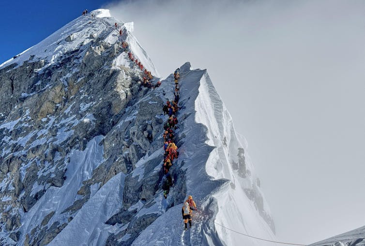
In the 30 years after Edmund Hillary and Sherpa Tenzing Norgay first stood at the summit, only 150 men and women matched their feat. But since then, the number of climbers has sky-rocketed. In 2019, a record 877 people summited the mountain, and in 2024 ascents were only just shy of this.
Rebecca Stephens, the first British woman to climb Everest in 1993, has described how the “global obsession with the world’s highest mountain is shaping its future and the future of the people who work on it”.
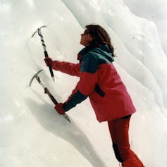
Stephens said her ascent in 1993, when there was only one commercial expedition on the mountain, felt like a watershed moment. Since then, commercial expeditions have mushroomed on Everest’s southern base camp on the Khumbu glacier (altitude: 5,364 metres), which now boasts a wide range of facilities including coffee shops and party tents.
The explosion of interest in climbing Everest has been aided by the fact that, despite its altitude and dangers, it is far from the most difficult high-altitude mountain. A member of the Tibet Mountaineering Association who had summited five times told me, on a good day, Everest was “very straightforward” – and that climbing Denali in Alaska (North America’s tallest peak) had been much more difficult.
By the end of 2024, there had been 12,884 ascents and 335 deaths on Everest, a survival rate of 97.4%. But the so-called “death zone” above 8,000 metres, combined with avalanches, extreme weather and frostbite, will always present significant hazards to the people who visit these slopes.
This climbing season, a Scottish former marine described quitting his attempt 800 metres below the summit after encountering two dead climbers. Meanwhile, four other ex-British special forces soldiers including UK government minister Alastair Carns used xenon gas and hypoxia training to travel to Everest and summit in under a week – leading to concerns that this could further increase the number of people attempting to scale the increasingly crowded mountain.
But while images of high-altitude queues and stories of occasional fatalities hog the headlines, most visitors to Everest do not attempt to climb it. And by far the majority of these tourists are on the “other side of Everest”, in China-administered Tibet.
China’s “economic miracle”, combined with its desire to develop peripheral regions, has meant that Qomolangma (the Tibetan name for Everest) is now easily accessible, with tarmacked roads all the way to the northern base camp at Rongbuk (altitude: 5,150 metres).
From having lower numbers of visitors than the Nepalese side 20 years ago, the Tibetan side of Everest now welcomes more than half a million tourists a year – the vast majority from mainland China. Short Chinese holidays mean most of these visits are whistlestop trips that also take in the nearby high-altitude cities of Lhasa and Shigatse. Because of the lack of altitude acclimatisation time, many tourists carry oxygen bottles or wear oxygen backpacks during their visits.
Retracing the earliest routes
To better understand the impact of tourism on Everest, I visited the Tibetan side in June 2024 as a guest of Linsheng Zhong, professor of human and tourism geography at China’s Institute of Geographical Sciences and Natural Resources Research.
The date of our visit was significant, being a century since the disappearance of early Everest adventurers George Mallory and Sandy Irvine on June 8 1924. We set out to examine both the human and environmental changes that have occurred over the intervening hundred years – using century-old journals and photographs as a baseline.
As geographers rather than high-altitude mountaineers, our aim was to retrace some of the reconnaissance routes used by the British in the 1920s – a time when Nepal was closed to foreign visitors. Between 1921 and 1924, three expeditions organised by the Royal Geographical Society and the Alpine Club visited Tibet with the aim of being the first recorded people to climb Mount Everest. None, as far as we know, reached the top – and the remains of the two leaders of the final expedition, Mallory and Irvine, were only discovered on Everest many years later.
While the vistas are equally spectacular today, climate change has had a significant impact on glaciers throughout the region. Recent scientific estimates suggest that there has been between a 26% and 28% reduction in the glaciers surrounding Everest between the 1970s and 2010.
In 1921, the leader of the first expedition, Charles Howard-Bury, camped just below the Langma pass – the highest but most direct easterly route to Everest – and photographed “a peak of black rock with a glacier just below it”. It is apparent from this “slider” comparison, using a photograph I took from the same spot, how much this hanging glacier has retreated over the past century.
The human impact on Everest
Everest’s permanent northern base camp at Rongbuk in Tibet now welcomes up to 3,000 visitors a day in high season. Tourists are initially disgorged into a regimented tented village – modern versions of Tibetan yak herder accommodation.
Some of these jet-black tents, made from thick yak hair which breathes when dry and is waterproof when wet, provide simple (but heated and oxygenated) accommodation for the hardier tourists who want to be at the mountain early for the best photo opportunities.
Wandering up the astroturf lining the central boulevard, we meet a range of souvenir sellers before reaching the “world’s highest post office” and a circular plaza commemorating the various scientific and political achievements of the region. The near-landscape is largely brown: when he was here, Mallory described the contrast between the rain-shadowed “monotonously dreary, stony wastes” of Rongbuk with the beauty of the snowy mountains looming above.
Today, a boardwalk takes tourists marginally further to Rongbuk monastery – founded in 1902 and rebuilt after being damaged during the Chinese Cultural Revolution – and a final viewpoint of the north face of Everest. A yellow sandstone band is clearly visible just below the summit – evidence that this mighty mountain was once at the bottom of the ocean.
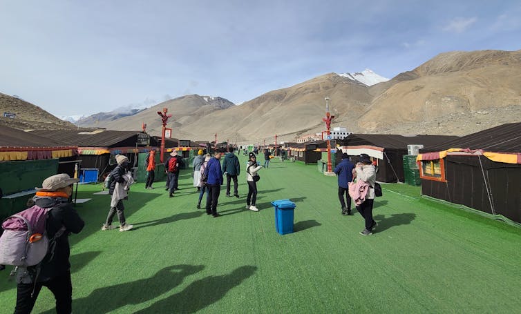
The mood on our trip was a sharp contrast to my visit in November 2007, when our Tibetan guide had been keen to evade any security checkpoints (albeit to maximise his personal profit, rather than any ethical standpoint). With only a few thousand annual, mostly international, visitors, the facilities back then were very limited, beyond a warning to tourists to proceed no further or face significant fines – and a shiny new sign proclaiming mobile phone coverage.
However, we were able to walk to the snout of the Rongbuk glacier, a jumble of shattered sandstone rocks at the terminal moraine. Today, tourists cannot go far beyond the monastery and are corralled on new boardwalks.
Tourism has brought rapid economic change to this region of the Tibetan plateau – including diversifying from traditional livelihoods. Central government efforts to reduce overgrazing in the fragile ecosystem have led to a system of payments to traditional herders – and a drop in livestock numbers from a peak of nearly 1 million in 2008 to below 700,000 today.
In contrast, the permanent human population of the Qomolangma National Nature Preserve (the protected area that includes the Tibetan side of Everest) has more than doubled since the 1950s to more than 120,000 people, with especially accelerated growth over the last decade coinciding with the rise in tourism. The Pang La pass which crosses into the Rongbuk valley, described as “desolate” by English mountaineer Alan Hinkes in the 1980s, is now festooned with souvenir shops and mobile coffee baristas.
Concern about the environmental impacts of these tourists led to the introduction of a fleet of electric buses in 2019, with visitors instructed to park their vehicles in the small town of Tashi Dzom before taking a 30-minute electric bus ride to the northern Everest base camp.
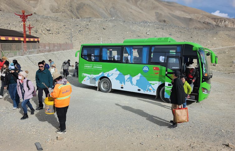
Now there are plans to move the bus transfer station to a gleaming new park centre closer to the main highway, to save tourists having to drive the numerous switchbacks over the Pang La pass to Tashi Dzom, then negotiate traffic jams and parking challenges nearer the peak.
This is partly to cope with another western import to China: the concept of the “road trip”. For Chinese car enthusiasts, the 5,000-kilometre Route 318 from Shanghai to the foot of Everest is now one of their most popular long-distance drives.
‘The most beautiful valley in the world’
We visited the east and north faces of Everest in Tibet armed with photographs and accounts from those three early British expeditions more than a century ago – the first recorded attempts to climb the world’s highest mountain.
The first (1921) expedition led by Howard-Bury, an army lieutenant-colonel, botanist and future Conservative MP, was a detailed scientific and topographical survey of the area. In their attempts to find a route to the summit, approaches via the northern (Rongbuk) and eastern (Kama) valleys were reconnoitred.
Although less visited than the Khumbu base camp in Nepal or the Rongbuk base camp in Tibet, the eastern approach to Everest via the Kama valley is a wonderful trek with unobstructed views of the immense eastern face of Everest. Howard-Bury described the allure of the valley which remains today:
We had not been able to gather much information locally about Mount Everest. A few of the shepherds said that they had heard that there was a great mountain in the next valley to the south … They called this the Kama valley, and little did we realise at the time that in it, we were going to find one of the most beautiful valleys in the world.
The valley is accessed from the settlement of Kharta, a small-but-booming town on the banks of the Bong Chu-Arun river. Just below Kharta, the river enters a steep gorge, dropping from nearly 4,000m to 2,000m as it enters Nepal. Today, the Kama valley route is becoming popular with Chinese trekkers, although there are very limited facilities to deal with their impact on the area – notably, the human and plastic waste.
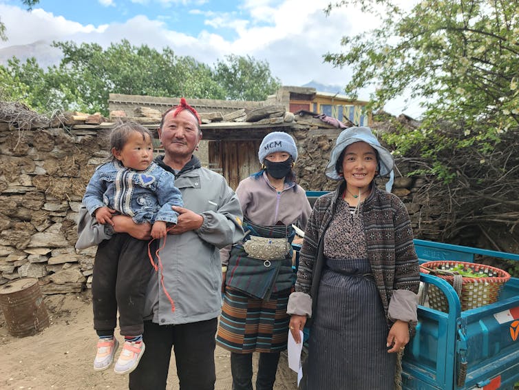
The 1921 expedition selected Kharta as the location of its second base camp after several months of exploration at Rongbuk. All were relieved to find such an amenable climate and greenery after the dry and cold of the Tibetan plateau. With the help of the dzongpen (village head) and a local fixer, they rented a farmhouse where many of the photos from the expedition were later developed. Located in a grove of poplar and willow with small streams trickling along its boundary, we also visited this farmhouse – now owned by a Tibetan farmer who cheerily showed us around and introduced the three generations of his family.
The British expeditions’ investigations of the Kama valley are of particular interest as this valley sits on the climatic boundary between drier and wetter areas to the north and south of the Himalayan range. Howard-Bury described thick mists coming up the Kama valley each evening, providing significant moisture to the region:
As usual, in the evening, the clouds came up and enveloped us in a thick mist … When we started the following morning, there was still a thick Scotch mist which made the vegetation very wet … On the opposite side of the valley were immense black cliffs descending sheer for many thousand feet.
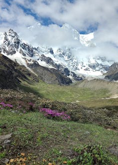
Still evident today, this precipitation, combined with great variations in altitude and temperature, supports a profusion of plants – as well as animal life that our predecessors described as “extraordinarily tame”. Now as then, in summer, the hillsides are covered with the yellow, white and pink flowers of rhododendrons and azealas, and huge juniper trees grow in the lower valley. Howard-Bury described spending “the whole afternoon lying among the rhododendrons at 15,000 feet – admiring the beautiful glimpses of these mighty peaks revealed by occasional breaks among the fleecy clouds”.
Adorned with prayer flags, the high passes are still used by local people as portals to the sacred Kama valley. In 1921, when he crossed the Langma pass to enter this “sanctuary”, Mallory wrote that the grumblings of his previously stubborn porters had suddenly transformed into “great friendliness” and “splendid marching” – such that they were “undepressed with the gloomy circumstance of again encamping in the rain”. Descending into the Kama valley, Howard-Bury effused:
To the west, our gaze encountered a most wonderful amphitheatre of peaks and glaciers. Three great glaciers almost met in the deep green valley that lay at our feet. One of these glaciers evidently came down from Mount Everest.
While the topography here remains largely unchanged, the very significant reduction in the volume of the central glacier is evident in these comparison images:
In 1921, the expedition wrote that the outflow from the Kangshung glacier (which descends from Everest) had to “hurl itself into a great ice cavern” in order to flow under the Kandoshang glacier (from Makalu, the world’s fifth-highest peak) and become the Kama river. Today, as a result of glacial retreat, that ice cavern is no longer present and the main stream from the Kangshung glacier flows unimpeded along the snout of the Kangdoshang glacier.
Further up the valley, the 1921 expedition established another base camp in the high meadows towards the head of the valley at Pethang Ringmo, which, as well as a final camp stop for trekking groups today, remains an important grazing area for migratory yak herders. These herders were important sources of information for the early explorers, but today there is some evidence of overgrazing. Howard-Bury commented:
We found ourselves among pleasant grassy meadows – it was a most delightfully sunny spot at 16,400 feet, right under the gigantic and marvellously beautiful cliffs of Chomolönzo – now all powdered over with the fresh snow of the night before and only separated from us by the Kangshung glacier, here about a mile wide. Great avalanches thunder down its sides all day long with a terrifying sound.
A century later, avalanches continue to show us this is a dynamic landscape in a state of constant flux. Often, we would glimpse the rapid tumbling of ice and snow in a long white cloud, rushing down the steep couloirs seconds before the terrifying sound reaches you – reminding us of one of the major threats to climbers.
At the head of the Kama valley, the Kangshung face of Everest is perhaps the most impressive of all the sides of the mountain, towering some two miles above the glacier below. Both the north-east (Tibetan) and south-east (Nepalese) ridges – the most popular routes to the summit – are clearly visible from here. The Kangshung face itself was not climbed successfully until an assault by an American team in 1983, and the first British ascent of Everest without oxygen by Stephen Venables in 1988.
While initially, the mountains and peaks look remarkably similar to the 1920s, the drop in the level of the glacier quickly becomes apparent. The ordered glacial flow has been replaced by rocky detritus and numerous perched lakes, leaving a lunar-like landscape.
During his first visit, and despite having spent much of his life in the mountains of Europe, Mallory wrote that he was in awe of the vista here:
Perhaps the astonishing charm and beauty here lie in the complications half-hidden behind a mask of apparent simplicity, so that one’s eye never tires of following up the lines of the great arêtes, of following down the arms pushed out from their great shoulders, and of following along the broken edge of the hanging glacier covering the upper half of this eastern face of Everest.
While Everest was the prize sought by all the expeditions, the sight of the Makalu massif, dominating the Kama valley to the south, appears to have had a greater impact on both the climbers. Howard-Bury claimed it was by “far the more beautiful mountain of the two”, while Mallory “saw a scene of magnificence and splendour even more remarkable than the facts suggest”. He wrote:
Among all the mountains I have seen, and, if we may judge by photographs, all that ever have been seen, Makalu is incomparable for its spectacular and rugged grandeur. It was significant to us that the astonishing precipices rising above us on the far side of the glacier as we looked across from our camp – a terrific awe-inspiring sweep of snow-bound rocks – were the sides not so much of an individual mountain, but rather of a gigantic bastion or outwork defending Makalu.
In fact, according to Howard-Bury, “the shepherds would insist that Makalu was the higher of the two mountains, and would not believe us when we said that Mount Everest was the higher”.
The future of the Everest region
This historical comparison of hundred-year-old images and quotes represents both the enduring mountains but also the rapid changes that the Himalayas now face. Forces of tourism on one hand and climate change on the other are posing huge challenges for these marginal environments.
Our research shows that tourist and climbing activity is having significant impacts on the region. The causes are both directly at the mountain but also at home, particularly in the damage that all of our consumptive lifestyles are having on Himalayan glaciers.
Of course, these activities have also brought much-needed development opportunities to local populations, and the residents of both the Nepalese and Tibetan sides are generally much better off than populations in less-visited areas of their respective countries.
The expected redesignation of the Qomolangma National Nature Preserve as a national park in the current Chinese central government plan may bring opportunities for further management locally as the crowds continue to grow. However, we also identified a shortfall in protecting the significant cultural heritage and longstanding spiritual relationship to the mountain, which is often eclipsed by its physical size.
Perhaps a more balanced relationship to the mountain and its people is required, one that reevaluates our rather unhealthy obsession with just one peak. Reading the accounts from the 1920s, one is aware that there was a deep reverence for the region – not only from local people but also from its British visitors.
In the intervening years, summit bids on the Tibetan side have historically been much lower than in Nepal. Closed to outsiders for much of the latter half of the last century, Tibetan ascents briefly became more popular in the 1990s and 2000s, with a few well-organised commercial operators. But closures in 2008 during Olympic preparations, and again during the COVID pandemic from 2020 to 2023, once again meant a much-reduced number of attempts.
Combined with less reliance on foreign exchange, China has been able to exert much more control on the climbing industry, and in 2024 did not charge a permit fee at all, preferring to ensure climbers were appropriately experienced. There may be merit in this approach, as no one was killed on the Tibetan side in 2024, as opposed to the eight climbers who perished on the southern side.
But on both sides of the mountain, it is highly unlikely that our global obsession with Everest will wane. As longtime chronicler Alan Arnette notes, the mountain has an “immutable attraction that is oddly perverse”. So, it is important we continue to monitor the changes in this dynamic landscape wrought by both its visitors and climate change.
To counter the rising commercialisation of both mountaineering and mountain tourism requires, above all, greater respect for our mountains and the people who reside on them. According to Lakhpa Puti Sherpa, president of the Nepal Mountain Academy, notes:
The Himalayan mountains are holy spots – and we, the Sherpas, worship them. Before climbing any mountain we worship it, begging apologies on having to step on it on the top, and asking to absolve the sin we are going to incur from this particular violence.
Watch more image comparisons of the Everest expeditions here. All historical photographs are published courtesy of the Royal Geographical Society. Slider comparisons built using Juxtapose.

For you: more from our Insights series:
To hear about the latest Insights articles and much more besides, join the hundreds of thousands of people who subscribe to our daily newsletter.





 English (US) ·